The northern coastal road between the town of Akka and the Lebanon border carries you past, through and upon the remains of several Palestinian villages depopulated in the Nakba. Almost all were destroyed soon after their populations were expelled. In June 1948 the “Transfer Committee” issued a memorandum entitled ‘Retroactive Transfer: A Scheme for the Solution of the Arab Question in Israel’ in which it saw ‘preventing the Arabs from returning to their places’ as best achieved by the ‘destruction of villages as much as is possible… [and] settlement of Jews in a number of villages and towns so that no ‘vacuum’ is created.’
Destruction can be read as a pragmatic tool to consolidate expulsion. But it was also part of a wider project of re-writing the landscape in accordance with an exclusivist nationalist logic. This logic demanded the physical terrain be re-inscribed in such a way as to affirm the uncontested proprietorship of the colonising power while erasing physical evidence of the colonised and expelled. Within this destruction is a creative process of re-authoring space, appropriating and reinterpreting its features. And this creative-destructive work holds within it opportunities for the re-crafting of space to meet the symbolic requirements of nationalist claims made upon it, and in particular those that mobilise romantic tropes of continuity or organicism,
Immediately following the Nakba, state-academic organisations such as the ‘Naming Committee’ were established to re-write the map of Palestine, assigning thousands of Hebrew names to topographic features and localities throughout the country, as Arabic names for springs, rivers, hills, valleys, villages and towns were buried. Prime Minister Ben-Gurion declared at the time: ‘Just as we do not recognise the Arabs’ political proprietorship of the land, we also do not recognize their spatial proprietorship and their names’ (in Benvenisti 2000). Legislation demanded that only new names be used in officialdom; this had the effect of compelling even those Palestinians who had escaped the cleansing to participate in the propagation of the new zionist spatial taxonomy, as the registration of births, deaths, marriages, vehicles and even efforts to defend the confiscation of properties demanded their use of the new names. This was an effect observed with satisfaction by government officials. Minister Alexander Dotan, in 1952, noted that ‘it is possible, by being strictly formal and with adequate indoctrination… to make the Arab inhabitants of “Rami” get used to calling their village, in speech and writing, Ha-Rama…’ (in Piterberg 2001).
The ‘Naming Committee’ was keen on biblical names which granted the new map an appeal to antiquity. They were uncomfortable with names which referenced modern European zionist history, rejecting a number of proposals by newly settled zionists which reflected their recent origins in Europe. Thus, the avowedly secular regime advanced a policy of naming which conjured the mythistory of ‘return’ to the ancient biblical ‘Land of Israel.’ Hence, the formal mandate of the Committee was ‘to provide concrete substance to the unsevered thread of historical continuity from the time of Yoshua Ben Nun through to the conquest of the Negev in our generation’ (in Benvenisti 1997). The fact that the committee could find relatively little evidence capable of fabricating this trajectory posed a problem (the area of pre-1967 Israeli rule being of marginal if any relevance in the Book of Joshua). The challenge was met with creativity however, and the Committee was soon able to “discover” locations amid the debris of Palestine which, apparently overlooked by numerous and extensive archaeological explorations prior to 1948, were revealed to be remarkable examples of Jewish antiquity.

Remains of Az-Zib in the 'Achzib National Park'
Rarely supported by archaeological evidence of any description, such sites emerged from the landscape via the often tenuous ‘research’ of the state-appointed committee. Often, an Arabic name’s phonetic proximity to a biblical Hebrew locality would suffice as the basis for assertions which would later be treated with extreme skepticism by even the most nationalist of Israeli archaeologists and biblical historians. The example of Az-Zib, a Palestinian fishing port a little south of the Lebanon border is paradigmatic in this regard. Depopulated in 1948, the area was re-named Achzib (or Achziv) by the Committee, which maintained that the Arabic name derived from this biblical name listed in the book of Joshua. Although the housing, place of worship and cemetery of the Palestinian locality were destroyed, the remains were, with the name, instantly translated into markers of Jewish proprietorship, continuity, and ‘return’.

Picnic table and original wall - 'Achzib National Park'
Never taken particularly seriously by archaeologists or historians, the site’s remaining arches, domed roofs, and miscellaneous architectural remnants have since been transformed into a small national park, complete with snackshop and picnic facilities. None of the remaining structures are identified or dated. Instead a small plaque at the entrance to the site simply declares Achzib to be the site of a Jewish community in biblical times, referring the inquisitive to the book of Joshua should any further details be required.

Welcome to 'Achzib Land'
Adjacent to the national park, an entrepreneurial couple have established the bizarre ‘Achzib Land,’ a fenced enclosure wherein more of the village’s debris has been rearranged in the spirit of a rustic outdoor restaurant. For a fee, newlyweds are shuttled in to have portraits and videos taken against a mélange of curious artifacts and structures reassembled to blur any immediate national or historic recognition, and to instead convey a sort of timeless rural antiquity. The entire enclosure can be hired for catered receptions or similar events.
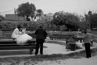
There was a Wedding in 'Achzib Land'


There were several
The northern perimeter fence of ‘Achzib Land’ is hidden behind a string of wooden service huts. They conceal also the littered remains of the village’s cemetery. ‘Achzib Land’ in fact is itself partially built over the destroyed graves of Az-Zib. Through a gap in the fence, it’s possible to make your way through upturned drums of coagulated chemical waste, over piles of rusted piping, discarded crates, plastic bottles, and to pick your way between the scattered stones of the cemetery. A handful of grave markers remain intact, but the overwhelming majority have been demolished; what remains is an eerie field littered with cut stones and compacted waste.

Remains of the Az-Zib Cemetary

Scattered gravestones and litter adjacent to the 'Achzib Land' fence
In re-inscribing Az-Zib as a marker of biblical continuity, zionism’s colonial technicians conducted the rapid and concentrated nationalizing work incumbent upon them at the time. The successful de-Palestinising of the physical remains of the razed village saw them loosely relocated within a vague teleology that purported to speak of primordial Jewish roots and contemporary ‘return’. At the level of its abstraction, space was simultaneously re-inscribed as the Hebrew Map (completed 1952) and Atlas of Israel (described as ‘aimed to promote national causes’ by highlighting the ‘achievements of the state’ and ‘the heritage of the fathers’) were generated as the legally mandated spatial devices through which the territory and its features were to be apprehended. But in the ensuing decades, Achzib’s predictable failure to elicit genuine recognition of its antiquity and significance combined with the emergence of new forms of national spatial practice. Where an archaeological dig might have prompted an awkward moment of reckoning, the exercise of an entirely different (and far more pervasive) form of nationalising agency can now be discerned in the treks, picnics, swimming outings, weddings and such which bring ‘Achzib National Park’ and ‘Achzib Land’ to life in its de-historicised, aesthetically rearranged and politically “neutralized” guise. Az-Zib’s reordered masonry is now safe enough to appear behind smiling newlyweds in albums across the northern Galilee. Families can picnic and swim beside the village’s domes and arches safe in the vague nationalising claims contained in the park’s name and plaque, and in the national flag that flies above it. The fact that few will peer behind the fence and recognize there the cemetery of a depopulated village is a reflection of the normalizing power of this process of reinscription when carried out in similar fashion at a macro level across the entire country.

Foreground: Az-Zib graves. In rear: 'Achzib Land' wedding 'throne' for portraits
 I will shortly be posting something to do with Melanie Philips, her current trip to the Holy Land, her undoubtedly constructive intentions, and the distinguished company she's been keeping here. In the meantime. nd as you ask. Here's another variation: